
What is happening with the Mike Turtur Bikeway Overpass?
- Sep 16, 2022
- 8 min read
The Mike Turtur Bikeway Overpass project is a vital link in our cycling network. If realised, it will greatly improve safety for locals and visitors alike in crossing the train line at Goodwood. What is more, in facilitating safe, convenient travel by bike it will also contribute to our pressing need to promote more sustainable forms of transport - and reduce car traffic in the process!


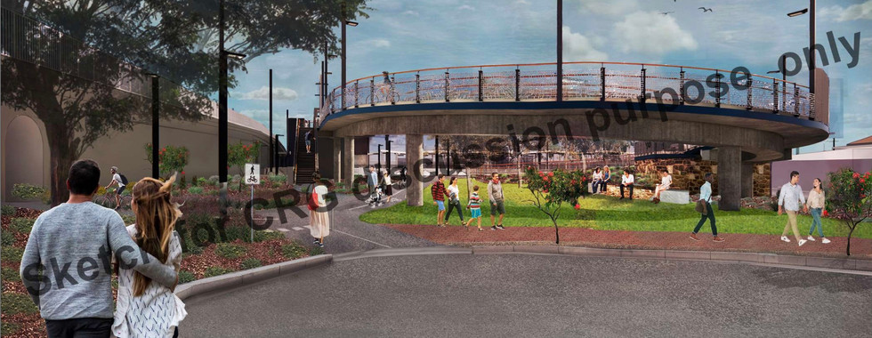


(Renders of the initially proposed overpass, shared publicly as part of the CRG process)
Many of you may not know that the Unley Bicycle User Group was founded in 1990 with the mission of creating a safe, separated bikeway along the tram line through Unley. 30 years later, the Mike Turtur Bikeway is well known and arguably one of the state’s most popular cycling routes. One of the final missing pieces of the Bikeway is the crossing of the Bikeway over the Seaford / Belair train tracks at Goodwood. Due to start construction this year, the project was delayed due to community concern over the design of the overpass. While the UBUG was supportive of the initial designs, we appreciate the genuine efforts from the government (the PTP alliance) to listen to the community and get the project right.
To this end, over the last several months we have been taking part in the Community Reference Group (CRG) that was set up to gain community feedback on the project proposal. This group, one of many key stakeholders that the project team has been consulting with, was given the opportunity to rethink the overpass project from first principles and come up with one (or more) suggestions to achieve the project’s two aims:
Improve connections for pedestrians and cyclists over the rail corridor, and
Improve equitable access to Goodwood train station, which does not currently have compliant wheelchair access.
The CRG process wound up a couple of weeks ago and we wanted to take the opportunity to fill in our members on where the process ended up as well as our thoughts on what transpired.
Firstly, the big outcome was that of the many ideas explored by the group, two main options emerged as possible solutions for meeting the project aims. We will go through them one by one, starting with the UBUG’s preferred option:
North Side Overpass

This is the route originally proposed by the PTPA project team late last year, with a few subtle but important modifications. It also emerged as the most favoured / least objectionable option for members of the CRG.
This route begins at the archway underpass on Railway Tce South, curves gently up a ramp through a newly-created park in a way similar to the Pym St Overpass over South Rd (refer image at the top of the page), and crosses the rail line where it then runs tight along the tram overpass at the edge of the reserve.
This design improves on the original 2021 proposal by:
Including the widening of the tight arched underpass in the project scope.
Hugging the tram overpass tightly to minimise visual impact on the park,
Having a wider ‘bridge’ section with dedicated cycling and walking lanes, and
Including an extra lift at each end to make it easier for people with wheelchairs, prams etc to cross without using the ramps.
These improvements are significant and the CRG group should be commended for getting them included in the project.
We on the UBUG committee believe this is the most favourable option for meeting the project aims and completing the Mike Turtur Bikeway. Our reasoning and some further thoughts are as follows:
This route has the most direct, most intuitive and safest connections to the major bike routes in the area:
Direct connection east-west on the MTB through the widened arched underpass in the east and Norman Tce in the west.
Connection from the MTB in the west with the Marino Rocks Greenway in the east (city side) for those who want to ride to the city along West Tce.
This is the safest option as there is no need to cross the tram line at grade - the existing arched underpass, widened (we strongly recommend) as part of the project, is used to good effect.
Riding along the edge of the Forestville Reserve and above the Goodwood Train Station provides important passive safety surveillance to and from the overpass, the reserve and the station.
A new park will be created on land purchased by DIT where the ramp curves down. This is huge for the eastern side of the train tracks, which is an area lacking in public green space generally.
This option does not cause more trees to be lost compared to other options. Tree impacts can further be minimised by routing the very western end of the ramp through part of Forestville Reserve’s overflow carpark. The community needs to decide what they value more: trees or an overflow carpark?
An option was presented where the eastern ramp runs straight down Railway Tce North instead of looping back around as shown in the image above. We do not think this is an optimal outcome because:
It will force users to cross the tram lines at an at-grade crossing (slow and unsafe) closer to Goodwood Rd, and
It provides poor connection to Marino Rocks Greenway along the showgrounds.
South Side Overpass

A suggestion was made by some CRG members that a crossing of the train lines to the south of the tram tracks might provide a more direct route for cyclists without impacting Forestville Reserve. However, upon closer inspection we strongly feel that this option would be a poor outcome for cyclists, park users, station users and nearby residents:
While the train lines will be crossed safely, cyclists will still have to cross the tram line to the west of the train tracks. They will ostensibly do this at a new automated level crossing near the intersection of Leah St, but this has several major problems:
The safest time for cyclists to cross the intersection at Leah St is when the tram boom gates are down and they can quickly continue their journey eastward. With this design, once they get across Leah street they will have to get across the tram line. If there is a tram coming - they have to wait for the tram to clear the crossing before they can proceed. This means there will be even more cyclists bunching at the western end of Norman Tce/Leah Street to get across the tram line. So they've just created one hell of a safety issue - and obliterated the concepts of cohesive, safe and direct from the five principles of best practice cycling networks.
Does not facilitate cyclists transferring to the Marino Rocks Greenway
The pedestrian / DDA access lifts on the south side of the tram line will be out of sight and unsafe. Likewise, the ramp overpass will also be unsafe for users due to the privacy screening needed to stop overlooking into the nearby houses. Contrast this to the north side option, with ample visibility to/from the ramps and overpass on all sides.
DIT will have to acquire all or part of the property on the South side of the tram line to facilitate the new ramp and lifts.
to do this they are likely to sell the property they own on the north side of the tram crossing to property developers (given its location they'll pay a premium) - so the idea of a fancy park in place of the Devon St North property is fantasy.
The same amount of trees will be lost as the north side option with no possibility of extra park given back to the community as in the north side option.
Underpass Option

Going into the CRG, many members as well as people in the wider community were of the opinion that an underpass would allow a crossing to be made while having minimal impact on the park. The CRG members thoroughly explored several underpass options at several locations, all of which were unanimously rejected after considering the impacts that an underpass would have on the reserve and surrounding area. A great deal of land would be required to be excavated and sloped to facilitate sightlines to and from the underpass, carving huge chunks out of the park and necessitating the removal of the popular skate park and basketball court. After all that effort, the underpass would still be less safe than an overpass because it would only be visible from areas immediately adjacent.
No project at all?
We resoundly reject the idea that the project should be shelved altogether. The Mike Turtur Bikeway is arguably Unley’s (and Adelaide’s!) most popular cycling route, providing an important commuter and recreational link between the city and Glenelg. The area around the Goodwood Station is the most confusing and unsafe part of the whole bikeway (with the exception of Jetty Rd and the entire Adelaide City section - get your act together CoA!). We know that just one confusing and unsafe part of a cycling route can stop people riding the route altogether, which is why it is so important that this project goes ahead.


(Pictured above are some of the dangerous situations that people on bikes, on foot or on wheels currently have to navigate in order to cross the train lines. Would you feel comfortable letting your young child navigate these spaces? Or an elderly relative? Images courtesy Apple Maps.)
Some members of the community have been spreading misinformation, citing usage numbers and questioning whether a project is necessary at all. This is disingenuous - one does not judge the need for a bridge by the number of people swimming across a river, as the saying goes! Infrastructure like this will by its very nature increase the number of people using the entire bikeway (and hence their bikes!) by a phenomenon known as induced demand. Getting more people on their bikes and out of their cars will be especially important given the continued population growth of the surrounding area and wider Adelaide in general.
Trees, green space and Forestville Reserve

Many people are rightly concerned about the impact that any project would have on the cherished green space at Forrestville Reserve. We at the UBUG are confident that, if realised, this project will actually have a net positive impact on green public space and biodiversity in the area for the following reasons:
There will be no net loss of green space within the reserve due to the greening of the carpark area as part of the project.
Most of the trees impacted were planted in late 2013 when works to the creek were undertaken.
There is potential to save even more trees by routing the western end of the path through the carpark (therefore sacrificing carpark space instead of trees)
An entirely new green space will be given over to the public in the government-owned land to the east of the train lines where the ramp goes down.
The new landscaping will be carefully considered and comprise of durable, local plants selected to improve biodiversity - source.
Next steps
We have been very impressed by DIT and the PTPA’s willingness to listen to the community as part of the CRG process, as well as their rigour in making sure all voices are heard, not just the loudest. To this end, the opinions of members of the CRG will be put together in a report that is presented to government as one of many inputs to consider. Importantly, the CRG was not expected to form a unanimous recommendation and all members’ viewpoints will be represented in the final report. The government will also take into account views from other stakeholders, budgetary matters and good ol’ politics before making a decision of how or whether the project goes ahead. You can bet the Unley Bicycle User Group will continue to keep everyone in the loop as to updates on the project as they happen!


What Unley Council Candidates think about active transport.
I would like to address the comment's made by Jane Russo, who is running as a candidate in Unley.
I quote" I am particular concerned about the MTBOP AND THE OVERRATED BLOWN- UP CONCERNED, that could generally result in no improvement being made to walking and cycling infrastructure to this area !!" end quote.
This overpass I believe you are referring to is NOT OVERRATED OR IS BLOWN UP. This is of great concern to this community. We are very passionate about this topic. For some reason you are saying we are against infrastructure for bike's you could NOT be more wrong ! We do see the need, but not in …
Propaganda through and through.
This is not a VITAL link to the cycling's network, that a very emotional view, stick to facets .How will this overpass reduces the traffic in the area! We have the Unley pool which brings it only challenges with parking already. The pool with lose 10 parking spaces thus putting more cars in the street, tell me how will an overpass reduce traffic ! The relocation of the basket ball court, taking away half of the only flat green space we have for other ball games ?You have the wrong demography group in your drawings of young children older teens use the courts. The ball games will be near the road in Ethel how do you intend to stop an…
My god I have run out of tissues, this is not a refreshing clear view of the project at all. This is purely propaganda to promote the views of a cycling group, who is in partnership with PTP Alliance to get this monster build. No matter how this is put to the community these people who will whiz pass on the bike overpass feeling very happy with them self's about what they have accomplished !! Not give thought to the community who would have spent 18 mths watching the destruction of the reserve. Where do you think these plans came from, who did them, I would think they would be for the DIT website and PTP Alliance, hand in h…
"Some members of the community have been spreading misinformation, citing usage numbers and questioning whether a project is necessary at all. This is disingenuous - one does not judge the need for a bridge by the number of people swimming across a river, as the saying goes!"
What is the misinformation?
Are the numbers cited by the latest survey correct?
In what way is it insincere and dishonest to question whether the project necessary?
And that "saying" ( made quite recently by Brent Toderian ) adds little to the evaluation of a complex problem. I wonder how Brent would solve the problem?